Further information
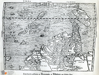
Sebastian Munster. Basle, 1554. 25.6 x 34.3 cm. Sebastian Munster (1489-1552) exerted an influence over geographical thinking in the middle of the 16th century as great as that exercised by the atlases of Ortelius and Mercator a generation later. This map was made by Munster and is part of the Carlos Quirino Collection archived in the Filipinas Heritage Library.

East Indies, 1554 (SC00287)
Short Description
Sebastian Munster. Basle, 1554. 25.6 x 34.3 cm. Sebastian Munster (1489-1552) exerted an influence over geographical thinking in the middle of the 16th century as great as that exercised by the atlases of Ortelius and Mercator a generation later. This map was made by Munster and is part of the Carlos Quirino Collection archived in the Filipinas Heritage Library.
Grade Level
K-6
Format
Image
Tags
Geography


